|
Half Dome - cable assisted climb to the top |
Hiking Yosemite National Park Home Pictures Books, Maps & Gear Na Pali Story Screensavers Feedback |
|
Summary: Humorous, illustrated story about the author's first, solo, overnight, backcountry experience hiking Yosemite National Park.
includes hiking Half Dome and Cloud's Rest as well as stops at Vernal Fall and Nevada Fall with lots of great Yosemite photos (show trail map).
(please note: this is not a guide)
Half Dome, Yosemite National Park - 2005 photo
Click images to see larger pictures. Click the Back button on your browser to return.
![]()
My first thought upon driving into
Yosemite National Park was "Ok, where's the visitor center/ranger station?" It's somewhere between a 3 and 4 hour drive from the Reno
airport to Tuolumne Meadows just inside the park's northeastern entrance.
It was early Monday evening and I was a little bit concerned that my
tentative plans for beginning a backcountry hike the next day were about to
change. I wasn't sure what time the
visitor center closed and I needed to talk to a ranger about the trip.
Specifically, I wanted to find out if my chosen route was a good choice
and I also needed to pick up the backcountry permit which I had reserved and
which was required for camping in the 'wilderness'.
Besides, I needed to use the bathroom.
I'd stopped at a gas station to top off the gas tank and fill the stove's
fuel bottle; but that was a long time ago.
Anyway, I paid the one-time entrance fee of $20 (per vehicle, per week)
and proceeded to look around for a place to pick up the backcountry camping
permit. There was a sign along the
road that read something like "Backcountry Permits" so I followed the
signs to a small booth occupied by a college student who would be working for a
few more weeks until school started in the fall.
I later discovered that there were a lot of college students working
there. Kind of like a little
community of them. I talked with
this dude for a while and told him I was thinking about hiking from Tuolumne
Meadows to 'The Valley', spending one night in the backcountry.
I'd catch the bus in the valley the next day and ride back to Tuolumne
where I had a camp site reserved all week.
He asked me what kind of shape I was in, what I wanted to see and
proceeded to suggest a different route which sounded shorter, easier and better.
I was all for it. He also
suggested that I get up early, drive to the valley, park the car and ride the
bus back up north to drop me at the trail head. The bus schedule wasn't
really compatible with my original plans. There's
only one bus that runs from the valley to Tuolumne Meadows and it leaves at 8am.
By leaving the car in the valley and having the bus drop me off at the
trail head, I could arrive back at the car anytime on Wednesday.
It's probably a good time to note that this was my first backcountry
camping experience. I hadn't done
this type of thing before; let alone by myself.
I just thought, quit worrying, it's only one night.
What's the worst that can happen? Even
if you ran out of food and water you 'probably' wouldn't die.
I'd been camping with friends and done a fair amount of hiking so was
pretty comfortable with the whole idea. Until...
the dude strongly suggested that I rent a bear canister. I'm like, huh? I'd
always thought that hanging food from trees and using bear canisters was simply
a safety precaution in the highly unlikely event that a bear was in this
particular area of the vast wilderness. Hikers
rarely see bears. People spend
their whole lives and never get to see one. This was news to me.
Ok, I'll rent the bear canister. It
was a big, heavy, hard plastic container within which I was advised to put
anything that smelled... food,
deodorant, toothpaste, etc. I was
then to place the canister away from the tent at night.
Bears, he said, might kick it around like a soccer ball but they won't be
able to get inside. Just don't
leave anything in your tent and you'll be fine.
The canister was about the size of my sleeping bag and I wasn't sure how
I was going to carry it. Ok,
whatever. I took the
canister, backcountry permit, parking permit (to leave my car in the valley)
& revised hiking route and left to find my Tuolumne Meadows camp site.
Along the way I decided to look around a bit first, buy some firewood and
check out the visitor center. The
visitor center was a small gift shop type outfit with picture books and post
cards employing more college kids. I
bought a few post cards and headed back towards the camping area.
I stopped at the convenience store/gas station on the way to buy
firewood. The store had just about
anything you could possibly want. Food,
groceries, wine, beer, camping gear, souvenirs, etc.
I had stopped at a K-Mart on my way to the park and bought a cheap
cooler, food, water, etc. I
could've bought everything here. You
could even buy hamburgers and other fast food.
 |
I used an older version of this book
along with advice from rangers and friends to plan my trip. It's an
all around good reference and includes information about lodging,
activities, hiking trails, camping and travel. Follow the link or
click the picture to
buy
it from Amazon.com.
I also used a topographic map by Wilderness Press while en route. It's printed on plastic, waterproof material and contains a lot of useful information on the back. This map can be purchased from Amazon.com at a lower cost than the Trails Illustrated maps. (click to buy it). Yosemite topographic maps can also be purchased from Trails Illustrated. Online map. |
I pulled into my campsite a short
time later.
Complete with fire pit and bear box (big, locking metal box for food)
this was where I'd spend Monday and Wednesday nights.
I'd succeeded in scattering all my food and gear all over the place when
I decided it was time to find the restrooms.
I hurriedly put 'most' of the food in the box and locked down the gear I
didn't want stolen (e.g. camera) and went to find the facilities.
They were nearby and it took me less than 10 minutes to return to camp to
find a pseudo ranger (college kid) preparing to write me a ticket for leaving
out a loaf of bread. I apologized
as she informed me that it was irresponsible to leave out food because the bears
become accustomed to the hand outs. The
bears then begin to rely on the food left out by campers, can no longer find
their own food in the wild, are no longer afraid of humans, become aggressive
and have to be killed. Ok... I
won't leave food out any more. Your
not even supposed to keep food in your car.
Bears will rip the doors off of cars to get food.
Put food in the big metal box. Okay,
okay... I got it.
I finally got the tent set up and was
ready to start a fire and make something to eat. I
pulled out the firewood purchased from the store.
Two boxes: one of hardwood that burns slower but longer and one of softer
wood that's supposedly easier to light but burns faster.
Note: in organized
campground settings, you pretty much have to buy firewood because there isn't
any laying around. It's already
been used up. I struggled to start
a fire. I didn't have a camp axe to
break the logs into smaller pieces and there was very little to gather as
kindling. I burned some paper and
trash but pretty much succeeded only in creating a smoking piece of shit.
Ok, time to eat. I'd bought some smoked turkey slices, chips and bread at the
store. Where's the bread?
Did the ranger confiscate it? Did
an animal (e.g. bear, raccoon) sneak off with it.
I have no idea. All I know
is, no bread equals slices of turkey and Nacho Cheese Doritos for dinner.
Not extremely satisfying; but I was hungry.
The travel alarm went off at 4:30am on Tuesday morning. It had been a cold night. I was pretty prepared; but one more layer of clothes and a warm hat would have been nice. It was late August/early September and the temperature at the higher elevation of Tuolumne Meadows was dropping to freezing. I remembered people talking in the convenience store about how cold it had gotten the previous night... now I know what they were talking about. I packed everything up and tried to keep everything organized in their proper stuff sacks. Clothes in red, dirty clothes in red... this became a problem later. Toiletries in green. Matches, knives, misc utility devices (silverware, garbage bags, etc.) in yellow. I'd bought a couple of gallons of drinking water the day before, so I filled up the water bladders, ate some breakfast bars, had a diet Pepsi and threw everything in the car (except for some of the food which I left in the box). I wanted to make sure that nobody took my camp site while I was gone so I put a little luggage lock on the bear box and tied a luggage tag to the outside. I figure, if anyone wanted the food bad enough they could get it; but at least they know the spot's taken and that I was planning to come back.
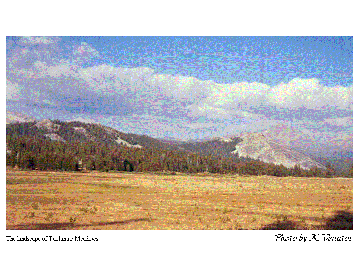 Landscape of Tuolumne Meadows Show
me the next picture
Landscape of Tuolumne Meadows Show
me the next picture
It's a 2 hour drive from Tuolumne Meadows to the valley
and the dude told me I should leave no later than 6am to catch the 8am bus.
I left at 6. The winding road runs through a variety of scenic areas (e.g.
Tenaya Lake, Olmsted Point, etc.); but I was in a hurry.
Not far from Tuolumne I got to see a bear crossing the road.
Cool. I eventually made my
way to the backcountry parking lot, put everything in the backpack and walked
down the road to catch the bus. I
purchased my ticket and waited for the bus to arrive.
I was pleasantly surprised to find out that the bus driver also
considered himself a tour guide. We
got a really nice description of many of the parks features, it's history and a
lesson about why naturally occurring forest fires are good and should be allowed
to burn. Without going into too
much detail, frequent and smaller fires clear off the forest floor, don't harm
the more mature trees and create a more livable habitat for animals. Frequent, smaller fires prevent large, hot burning fires that
kill the trees. Riding the bus that
morning were a couple of hikers who mentioned climbing Half Dome.
I was also planning to climb Half Dome.
They said it was really hard; but worth it.
Ok... what's 'really hard?' Can
I do it? What do you mean there's
cables up the side? What am I
supposed to do with my backpack? I
can't just leave it somewhere, can I? Hmmm.
Oh well, if they can do it, I can do it.
The bus backtracked the same route that I had taken to the valley from Tuolumne. It pulled over several times to drop hikers at different starting points. My chosen starting spot was the Sunrise trailhead about 3/4's the way back to my Tuolumne camp site. My original route was to hike the John Muir trail from Tuolumne all the way to the valley. Starting at the Sunrise trailhead is like taking a short cut to the cool stuff the on the John Muir trail. In fact, the Sunrise and John Muir trails merge in time to include all of the sites that I wanted to hit. AND the route is several miles shorter (yeah!). The John Muir trail is probably the most popular trail in a popular park. Named after influential naturalist John Muir, trail highlights include Clouds Rest, Half Dome, Nevada & Vernal Falls. It extends for a total of 211miles including large sections of Yosemite and Sequoia/Kings Canyon National Park to the north.
Show map.
I jumped off the bus and pulled my pack from the luggage
area underneath. I thanked the
driver and began to wonder... what am I getting into? At this point I noticed the smell of gasoline.
Oh, shit. The fuel bottle
leaked in my pack. I haven't even
started yet and am facing a pack full of contents soaked with fuel.
I pull the bottle out and immediately noticed the slick, coolness of
gasoline on the bottle and my hand. I
had borrowed a pillow from the airlines to use on the trip.
It was soaked. Luckily, the
pillow had prevented my clothes and sleeping bag from getting wet.
Everything reeked but it was dry. I
threw the pillow in a nearby dumpster, put the fuel bottle in a water bottle
holder on the outside of the pack and hoisted my barely used (and at this point
unjustified) purchase onto my back and headed into the wild.
Moral of the story:
make sure the fuel bottle o-ring is in tact and/or don't put the bottle
inside the pack.
Day time temperatures were pleasant.
I had learned on previous trips that convertible pants - the kind that
turn into shorts - are a good idea and that blue jeans suck.
It didn't take long before the pants turned to shorts and my lightweight
fleece jacked was tied to the pack. I
was sweating my ass off. My back
wasn't getting much air due to the close fitting pack and was drenched. A cool breeze made it chilly when I stopped to rest so I'd
have to put on the fleece. I found
it helpful just to tie the jacket onto the outside of the pack so I could grab
it anytime I got cold. This was
especially true on ridgelines where the wind was stronger.
The trail was well marked and it was a sunny day.
I would occasionally see other hikers and we'd exchange pleasantries.
"hi", "nice day, eh?" "what a great view!"
My goal for the day was to hike to the top of Cloud's Rest then down to a
stream and camp in between Cloud's Rest and Half Dome.
I passed water sources periodically and was never very low so water
availability didn't seem to be an issue. I
had purchased several plastic water bladders and looped a hose around to the
front of the pack where it clipped onto the shoulder strap.
An easily accessible compartment on the back proved very convenient for
storing a couple of the water bladders. I
soon arrived at a pretty little lake on the route and decided to take a break.
I stopped and drank some of my remaining water then proceeded to filter
water and refill the bottles. A few
minutes later a couple of California ladies strolled into sight.
I helped them filter water. They
were still wearing their packs and I was relatively well rested and mobile.
We then continued hiking together. They
were from L.A. and had started in Tuolumne the day before.
They were going to be hiking the same route as me but would be spending
another night in the backcountry at a camping area between Half Dome and Nevada
Fall called Little Yosemite Valley (you need reservations to camp there).
They considered my schedule pretty aggressive.
In retrospect, another night would have been a good idea.
My pace was a bit faster than the theirs and we became separated after a
while. I eventually closed in on
Cloud's Rest. The map indicated
that the trail splits just before the peak.
You could go up and over the top or go around.
It looked a bit challenging with a pack so I decided to leave my pack on
the ground, hike up to the top then come back, grab the pack and go around.
I scrambled over big rocks and along the ledge.
This part of the trail wasn't well marked.
I had some difficulty figuring how to get to the top without stranding
myself on some ledge that went nowhere. After
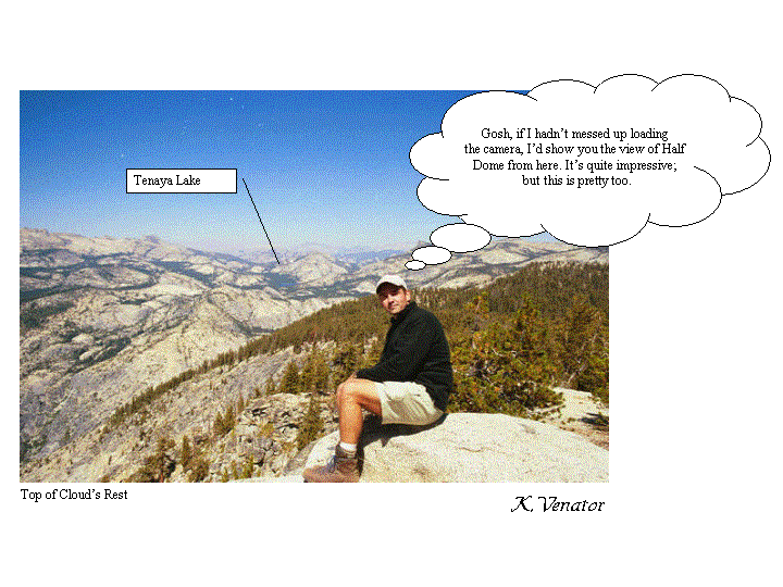
some trial and error, I emerged up onto the top with beautiful views all around.
Tenaya lake was visible in the distance and in the other direction, a
remarkable view of Half Dome. A
couple was sitting up on top in thermarest-made-chairs having lunch looking out
over the lower lying areas with Half Dome in the distance.
El Capitan could be seen farther off.
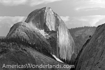
It was a wonderfully clear day and the scenery is very unique. Unlike the forests and mountains of Colorado, the Sierra Nevada's
of Yosemite have substantial areas of exposed white granite.
Two of the most well known of these rock formations are Half Dome and El
Capitan. El Capitan rises 3600 feet
straight up from the valley floor and is the largest single piece of exposed
granite in North America (if not the world).
Looking across the wide open expanse from the top of Cloud's Rest, it
appeared to be much 'whiter' (rockier) with less trees than other areas that I'd
seen. The rocky nature of the Nevada's
higher elevations results in more vistas and viewpoints than in other more
heavily forested areas. Rivers,
normally able to cut swaths through softer ground, tumble over the tall, rocky
cliffs in great waterfalls. 6 of
the USA's 11 tallest waterfalls are in Yosemite.
A similar concentration of large waterfalls can be found nowhere else in
the country. The forest thickens at
lower elevations. Earlier in the
day, the bus driver passed around a flier indicating the locations of a number
of forest fires (10-20) currently burning in the park.
All were controlled and intentional.
In areas closer to the fires, the views weren't as good due to the
lingering smoke.
 Top
of Cloud's Rest Show me the next
picture
Top
of Cloud's Rest Show me the next
picture
I took a look at the map and noted a stream near where
the trail splits for the out/back portion of climbing Half Dome.
I wanted to get to the stream, fill up with water and camp somewhere
nearby. My plan was to get up in
the morning, eat breakfast, pack up and not have to go very far before starting
the Half Dome ascent. I was heading down the side of Cloud's Rest when I passed a
group of guys placing big chunks of rocks next too each other in an effort to
build stairs into a steep portion of the trail.
My unsubstantiated theory is that this helps prevent erosion caused by
hikers sliding/stumbling down steep sections.
It's also safer.
I finally passed some water traveling across the trail.
A small pool, about half the size of a football was on the uphill side.
I stopped and sat down letting the weight of the pack rest on the ground.
I slowly maneuvered myself out of it, loosening the adjustable straps to
make it easier to take off and put on the pack.
I filled all of my water bladders (5 Liters) and was
going to camp at the first sight of a suitable spot.
Forget the stream, I'm done. The
problem with this part of the trail was that I was still relatively high up and
the sides of the mountains were pretty steep.
No clear, flat spots around. I
kept going. Finally the ground
began to level off and I found a spot that looked as if it had been used by a
previous hiker. This is it....
home for the night.
Until now I hadn't really thought much about being alone
in the woods. Now, with nothing to
distract me, I began to think about all the wild animals and psychos that might
be running around. I'd brought
along my cell phone and, surprisingly enough, it was working. I took the phone for safety reasons in case I fell or
something but it wouldn't be of any immediate help.
I had a small pocket knife and kept it handy but it was pretty worthless.
I also brought my pots and pans (cleaned of food) into the tent with me.
I'd overheard the staff at one of the visitor areas telling another
camper to bang the pots and pans together to scare off animals.
Better safe than sorry. I
looked at my trail map for a while and thought about the next day's events.
I would proceed to the stream, fill up with water, hide the pack behind a
rock then try climbing Half Dome.
On the back of the map was quite a bit of information
about the park including history, geology, camping regulations, tips, weather
and "Animal Problems." As
my flashlight danced across the page I was somewhat comforted to learn that
black bears are not considered to be especially dangerous. They didn't eat people and nobody has ever died in Yosemite
as a result of a black bear attack. Whew?!?
The next paragraph was about Mountain Lions.
Mountain lions, it said, have been sighted with increasing frequency, eat
people ("Unlike bears, lions may view you as food" ) and will stalk
solo hikers. Shit!!
It goes on to inform the reader how to survive the attack of a mountain
lion. First, avoid encounters with
mountain lions. Second, if attacked
by a lion, fight for your life because it's trying to eat you.
At this point I was getting tired of reading and tried to go to sleep.
Every little noise seemed amplified.
I found myself being alarmed by even the smallest noise.
Eventually, I realized that I was overreacting and I fell asleep.
"Stomp, STomp, STOmp, STOMp, STOMP!!!"
Something's outside, it's coming this way and it's big!
Oh Shit! I'm history. The headlines read: "Solo
Hiker in Yosemite Eaten by Bears and Mountain Lions."
It goes on to tell about my life, the history of animal attacks in the
park and finally concludes that you shouldn't hike alone without a gun.
Now would be a good time to note that hiking with guns
is a controversial topic and in some areas it's illegal. I'm undecided as to the merits of carrying firearms.
At any rate, I don't have a gun and my heart's racing.
I grabbed for my little pocket knife and was not at all reassured by it.
As the noise of big animal(s) came closer, I'd shout and bang the pots
and pans together. Bang,
Bang, Bang, "Get outta here!!" Kind
of like you'd yell at a stray dog getting into the trash.
Good, they're going away. Here
they come again... Bang, Bang,
Bang... "Go On!!
Get outta here!!!" I'm
guessing it was 2-3 bears; but I didn't see them.
I expected to hear them tearing at the canister, growling and fighting
with each other over the food; but they didn't.
They went away. It
took me a while to get back to sleep after that but I managed.
I had survived.
The next morning I got up, looked around for bears, made
breakfast, drank coffee and packed up all my stuff. It wasn't as cold at night as it had been at the higher
elevations in Tuolumne (elev. 8600'). The
morning was cool but not cold. I
was soon ready to go.
I made my way back to the trail and began heading for
the stream. The trail splits beyond
the stream. One direction continues
to the valley, the other to Half Dome. As
I made my way, I walked upon some deer grazing just off the trail.
They didn't seem to mind having their pictures taken so I snapped several
before moving on. I eventually reached the stream after passing some other
hikers camped along the way. I put
my pack down and filled all of my water bottles.
Another hiker was doing the same. We
greeted each other and talked a bit. I
asked if bears visited his camping area and he replied:
"oh yeah, they come around every night about 30-45 minutes after you
go to bed looking for food that you might have left lying around.
They don't stay long, just check things out and move on." Yep, that's consistent with my experience.
He then went on to tell me about a hiking experience in Alaska.
They have Grizzlies. Grizzlies
don't run away when their scared, they attack.
We continued to have a very pleasant discussion about our different
hiking adventures and things that we'd like to do in the future.
He headed back to his nearby campsite and I proceeded up the trail to
Half Dome. There were a lot more
people on this part of the trail. I
continued climbing while searching for a place to hide my pack.
I had to come back this way and didn't want to carry the pack clear to
the top and all the way back down. I
talked to others about hiding their packs and they all did it without being
overly concerned about loosing stuff.
I found a good spot just a bit away from a burned tree by the trail. I put the pack down and removed the top which converts into a
fanny-pack. I filled the fanny-pack
with food, water and few other things, hid the rest of the stuff and headed out.
While I spent time hiding the pack, a couple that I'd passed earlier had
passed me. I soon caught up with them.
"It's about time you ditched that pack, we were wondering if you were going to try and climb to the
top with it." "No."
I replied "just looking for a good hiding spot."
Seems as though they didn't waste any time getting rid of theirs.
I soon passed a rather bedraggled looking young guy.
He was carrying a small bag, a big bottle of water and a tired look on
his face. I greeted him as I passed
and kept moving. Up, Up, Up.
Persistent, steady, climb, climb, climb.
The out/back portion of the Half Dome hike is 2 miles each way from the
main trail. Much of the hike is a
long steady climb. It's not until
later that the earthen trail becomes stairs carved into the rock. Signs along the route warn climbers about lightning.
Lightning frequently strikes Half Dome.
If a storm's approaching, don't climb it.
If a storm overtakes you while your on top, stay low & stay there
(i.e. don't get near the cables). Another
sign talks about a rare species of salamander that lives on the top.
Don't mess with the salamanders. My
question: how did the salamanders
get there? It's out in the middle
of nowhere and a hell of a climb to the top.
Squirrels were up there too. I
didn't expect to see squirrels. They
must not be able to read the signs.
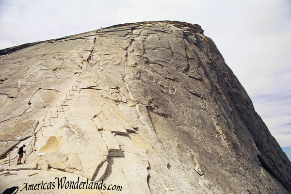
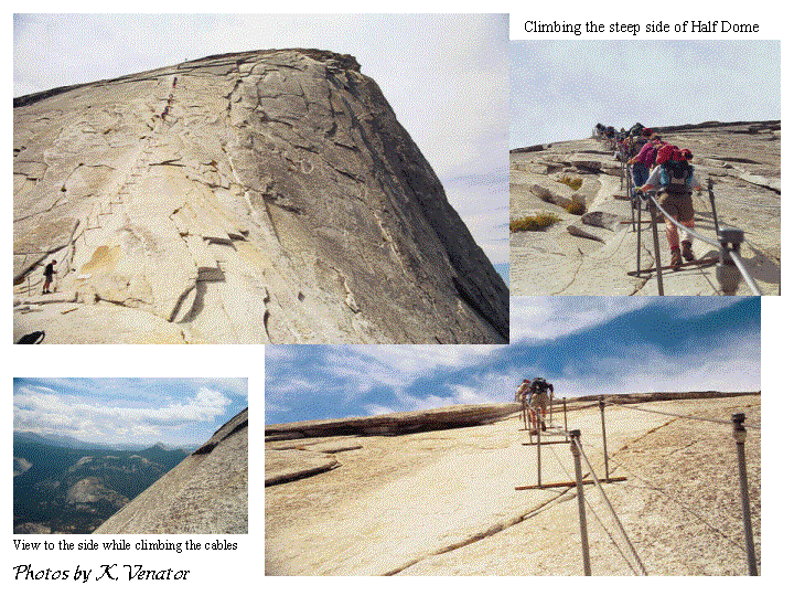
As I passed the end of the stairs, the trail continued
up and over a big, arching area of rock that ended at the last and most
challenging part of the route... the
steep side of Half Dome strung with cables.
Two 1" cables were held waist level by poles placed in holes in the
rock and spaced several strides apart. Boards
were anchored between the poles allowing footholds and places to rest.
I put on my gloves and began to climb; holding onto the cables and
sliding my hands along as I went. Step,
step, step, rest on the board. Step,
step, step, rest on the board. After
600' of climbing up the cables, I finally reached the end.
The ground started to level off and I proceeded up and onto the top to be
rewarded with extraordinary views all around.
The view of the valley 5000' below was nothing short of incredible.
I was standing on the top of one of the most prominent features of the
park. Mt Lyell is the highest point
in the park at an elevation of 13,114'. Cloud's
Rest tops out around 9926'. The top
of Half Dome is 8842' and offers rewarding views of both.
From the edge, you can look straight down a sheer drop off for 2,200
feet. The ground then begins to
slope outward, though still very steep, for another 2500'.
Adventurous hikers were walking clear up to the edge.
Other more cautious members of the crowd, like myself, would lie down on
our bellies and scoot to the edge to have a look.
There are no hand rails. A
rock overhang in one area juts out over the edge.
With nothing directly underneath, it offers an exhilarating experience
for those willing to give it a try. I
observed one guy lying on the rock looking over the side.
He stayed for a while then carefully made his way back to the relative
safety away from the edge. I had
talked with him briefly on the way up. He'd noticed that the fanny pack I
carried was from a Gregory pack. He
had the same kind. I asked him
about being out on the overhang. He
said it was cool but decided to move away after starting to get the willies.
The view was marvelous and I was trying to snap pictures over the side;
but I too was suffering from a mild case of the willies.
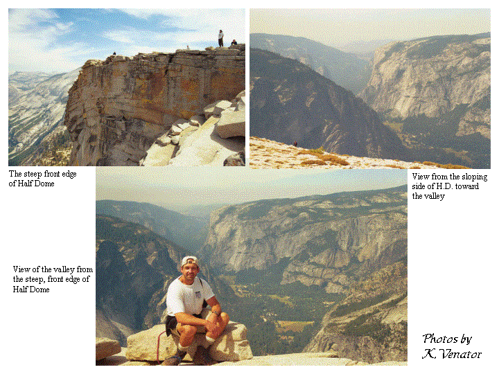

The top of Half Dome is a very large and relatively flat
expanse of barren rock. I walked
around for a while and sat down to enjoy the surroundings. I ate some trail mix, took in the view then started down.
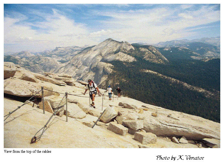
As I reached the top of the cables, I was asked by another hiker to take
his photo. He explained that a
buddy of his had been to the top and had convinced him to see it for himself.
As evidence of his accomplish, his buddy required a picture of him at the
top of the cables. Of course,
I obliged and he also took my photo.
 Cables on top of Half Dome Show
me the next picture
Cables on top of Half Dome Show
me the next picture
The descent was much easier than the climb.
I managed to get down very quickly.
On the way, I met the California ladies and we talked about our
experiences from the night before. I
offered words of encouragement for their impending climb then continued down.
I also met the couple with whom I'd talked on the top of Cloud's Rest the
day before, they were very nice. A
bunch of people were now reaching the bottom of the cables and were on the way
up. It seems that I'd timed my
climb to miss the throng of people now aspiring to reach the top.
A goal I had just achieved. I
was very happy.
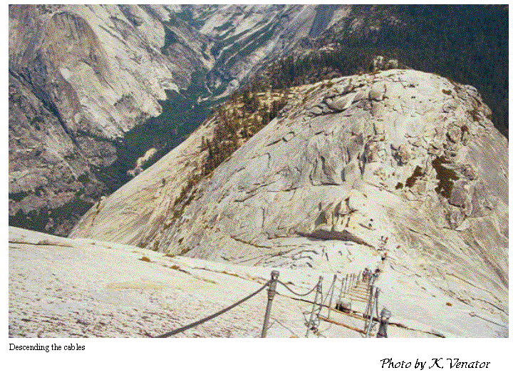 Descending the cables Show
me the next picture
Descending the cables Show
me the next picture
I was back on the trail and descending at the same time
as a man that I'd passed earlier on the way up.
We proceeded down together and met his wife who'd patiently waited while
her husband climbed to the top. They
were a very nice couple from Tucson and were the one's who'd previously
commented on me making the climb with my pack.
We talked as we headed down and went a considerable distance when we
began to realize that things looked different.
We'd taken a wrong turn. We
turned around, went back the way we came and eventually found the right trail.
We continued chatting and eventually came to the point where I'd hidden
the pack. We separated with
pleasantries. I reattached the top
portion of the pack, put it on and headed down.
I had a long way to go. My
goal was to hit Nevada and Vernal Falls en route to the valley.
I met the Tucson couple again where the trail split.
They were resting and eating a snack before heading a short distance to
the Little Yosemite Valley camp sites to spend the night.
I said my good-byes and continued.
From the top of Half Dome to the valley floor, it's a
downhill hike. It's almost a 5000'
vertical change in just over 8 miles. If
you think it sounds easy, think again. Normal strides aren't possible and the pack was still
bothering my shoulders. I never did
weigh the pack but let me tell you, it was heavy.
It was now late morning and I began to pass a new breed of hikers on
their way up. The others that I'd
passed earlier had camped somewhere close by.
These new folks were coming up all the way from the valley and some
looked wrecked. Most were novice
explorers that hadn't done anything like this before. Hey, I've been there. Unprepared
and ready to puke your guts out. Live and learn... it's
worth it. The bedraggled looking
fellow that I'd passed on the way up, caught me on the way down.
He was now a happy, bedraggled fellow.
He'd hiked all the way up from the valley and would hike down the same
day... that's 10000' feet of
vertical in 16.5 miles round trip. That
makes for a long day. He was a
college student from California on his way home to Pittsburgh.
He'd just decided to stop off in Yosemite for the day and do a little
hiking. He picked a good one.
We continued all the way to the valley together.
We passed through Little Yosemite Valley as we continued along the trail. The trail has been extensively used from here down to the
valley and has been hiked so frequently that in places it was like walking on a
dry, sandy beach. You'd step
forward, and while your weight moved over the top of your foot, the ground
underneath would shift. You use a
lot of extra energy walking on this stuff.
As we approached the top of Nevada Fall, you could hear
the sound of rushing water. Late
August in Yosemite is pretty dry. Fed
by snow melt throughout the spring and early summer, all the snow had long since
melted and a few of the water falls were either dry, or barely misting.
Fortunately, Nevada and Vernal falls still had substantial amounts of
water pouring over their rocky tops. Observation
areas on either side of the flowing stream allowed visitors to look over the
side of Nevada Fall to see the water plummet 594 feet.
Very nice. It must be
something to see the full force of the spring flow go over the top.
This is where the hike gets tough.
The last 3.4 miles from the top of Nevada Fall to the
valley were the most challenging. Lot's
of stairs and I was tired. Stair-stepping
switchbacks led from the top Nevada Fall until the slope began to level off.
Beautiful views of the front and sides of Nevada kept hikers company on
the way down. The trail continued
down to the top of Vernal Fall. An
observation area, similar to that at Nevada, lets observers catch Vernal's 317'
drop. The trail continues down stairs with cliffs on one side and
the rushing water on the other. This
portion of the trail is appropriately named the Mist Trail.
Clouds of mist float throughout the area and hikers in the springtime are
warned about getting wet. Continuing
down the trail along the side of the cliff, rainbows arch through the mist as
you look back at the waterfall.
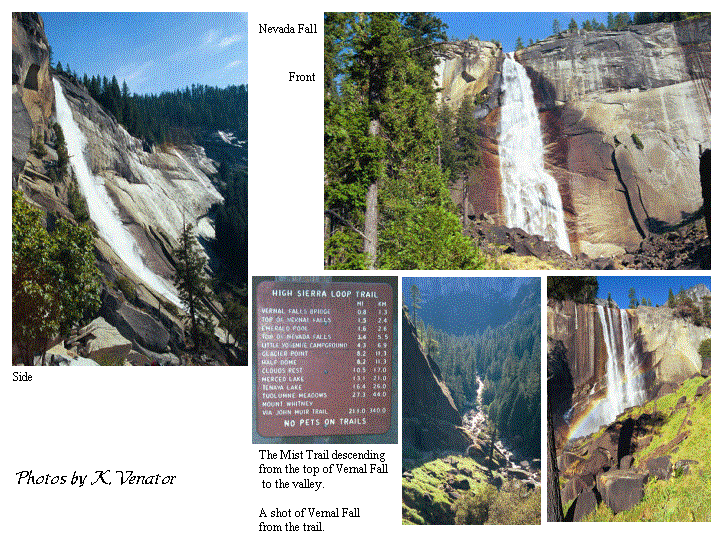 Mist Trail: including Nevada and Vernal Falls
Show me the next picture
Mist Trail: including Nevada and Vernal Falls
Show me the next picture
We continued down to the valley and I became more and
more encouraged upon seeing throngs of the unprepared hikers venturing up.
More people on the trail equals close to the end.
I enjoyed hiking with my college student friend.
As we stood at the bus stop along the road, I took my pack off and sat it
on the ground. Yeah, I did it. The bus soon came around to pick us up. Tourists riding the bus enjoyed the novelty of seeing
backpackers coming in from the wilderness.
I sat down in the comfortable bus seat and waited for my stop at Curry
Village, a camping area complete with souvenir shops, grocery stores,
restaurants, etc. The bus dropped
us off and we went into one of the shops. It
was early evening and I wanted to pick up a few souvenirs. Oh, a Half Dome hiker button... gotta have that!
T-shirts and postcards, had to get a few of those.
I walked out of the store and wished my new friend the best of luck.
I then headed for the car. I
took off the pack, and got out my tennis shoes. I didn't have any blisters - a pleasant surprise, but was
really happy to get the boots off. As
I sat against the trunk of the car, a couple of climbers walked by.
They were carrying long strands of climbing rope and had been on a hike
to scout a climbing route up the face of Half Dome.
Cool. I loaded everything up and drove around a little.
It was getting dark so couldn't see much.
I was also looking for a camp ax with which to chop some of the large
pieces of firewood I bought into smaller pieces of kindling.
They didn't have them anywhere. I
suspected that they'd have them back at the Tuolumne camp store but I wouldn't
make it before they closed. So
I stood in front of the multiple newspaper vending machines trying to figure out
which paper would be the biggest. I
bought 2 or 3 newspapers with the full intent of burning them.
I was going to have a fire this time damn it.
It was dark now so I began the 2 hour drive back to my
reserved Tuolumne camp site. It was
colder there. Tuolumne Meadows at
8600' is about 4000' higher than the valley floor.
The drive was uneventful and after arriving I set up the tent and started
a fire. The fire was nice and warm.
The fire pit had a cooking grill that you could flip over the fire so I
opened up a can of chili and sat it over the flames to warm.
It was soon ready to eat. Chili
wrapped in tortillas is good. I
also had some more Doritos and maybe a turkey sandwich (I also bought bread at
the store). It was now Wednesday
night. I had originally planned to
camp on Thursday night and get up really early Friday morning to drive back to
the Reno airport. I decided that
I'd have to get up REALLY early if I camped to catch my flight so I changed the
plan. I'd get up Thursday morning,
drive down the valley to check out the sites then drive back to Reno and check
into a hotel that night. I could
sleep later and clean up before getting on the plane.
One of the guys on the top of Half Dome recommended
visiting Glacier Point. I also
wanted to see a sequoia. I got up
Thursday morning and made some coffee and breakfast.
I've now become adept at using the stove.
I made a couple of sandwiches to take along for the trip then walked over
to greet my neighbors. They were
from England and on extended holiday. They
had already been in Yosemite for a couple of weeks and were planning to stay a
few more. I offered them the
remainder of my fuel, some bananas, hamburger, bread, remaining fire wood etc.
They were thrilled. Fresh
food is a luxury. A hikers diet
consists mostly of lightweight dry foods supplemented with some canned foods.
For example, ramen noodles and canned chicken. If you're near your car, you can have just about
anything; but not hiking in the woods. While
my neighbors had their car handy, they were college students on a very strict
budget and were loving the idea of hamburger and turkey.
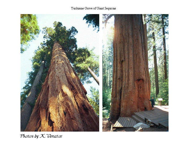
I soon headed for the valley. My intent was to drive to Glacier Point and then hit the
Tuolumne Grove of giant sequoias on the way back.
It's a smaller grove than Mariposa, less visited but on my route.
It took me a couple of hours to get to the valley.
I stopped along the way to get a picture of El Capitan.
On the bus ride up to Tuolumne, the driver had mentioned that a climber,
paralyzed from the waste down, had just climbed the face (3600'). Incredible. Shortly
after my visit, I learned of parachutists
jumping off the side. This
apparently happens a lot but had recently come under fire from park authorities
for being unsafe. In protest of the
crack down, a group of base jumpers made the leap.
One of them died.
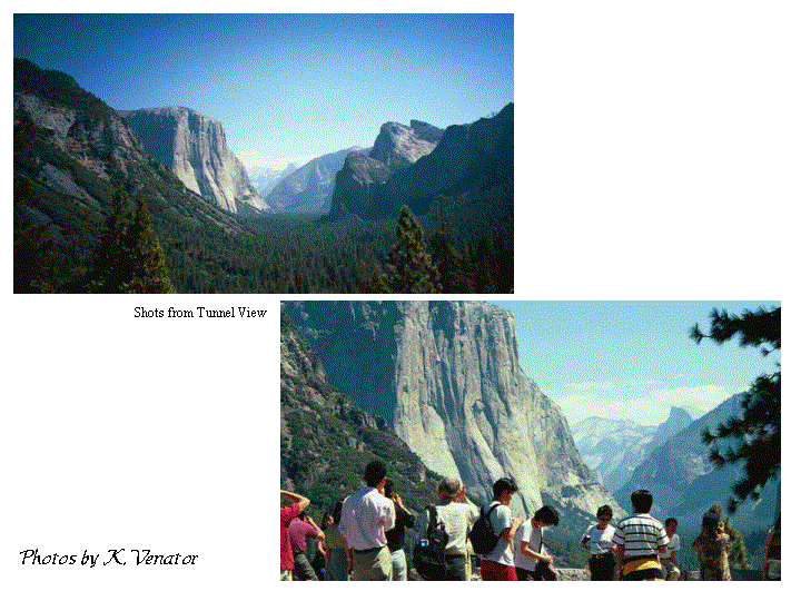
I proceeded en route to Glacier Point when I ran across
a view just on the outside of the Wawona Tunnel curiously enough called Tunnel
View. Wow! I had lunch here. Lots
of people and tour buses but a fabulous view with El Capitan rising on the left,
Bridalveil Fall on the right and Half Dome in the middle in the distance.
Along the route there were several other turnoffs and viewpoints to be
enjoyed. Several short hikes also
sounded great but there wasn't enough time.
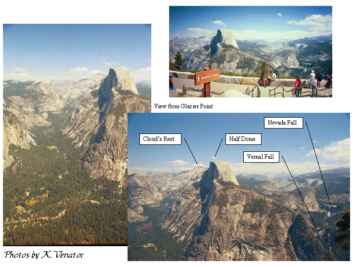
After several stops and beautiful views I arrived at the Glacier Point
parking area. It was everything I'd hoped.
From this viewpoint I could see my entire hiking route from the previous
2 days. From left to right, from
farthest to closest: Cloud's Rest, Half Dome, Nevada and Vernal Falls.
Neat. I took a lot of
pictures.
I headed back into and through the valley.
Other sites in the valley that I wanted to see included the Ahwahnee
Hotel (I drove by but didn't go inside) and the Ansel Adams gallery (I have a
couple pictures). I'll go back
someday.
The roads in and out of the valley are one-way,
multi-lane affairs. The in-route is
on the other side of the Merced river from the outbound portion. I was on my way out of the valley when I saw a group of cars
parked along the road so I stopped to have a look. Of course, the view was fantastic. I took a couple of pictures and moved on.
I was at a friend's place later and saw a painting of what I'd seen at
that viewpoint. Cool.
I also knew that one of my Ansel Adams photos was taken in Yosemite and
was keeping my fingers crossed that it was Half Dome (it might also have been El
Capitan, I wasn't sure). It was
Half Dome with the moon rising in the background.
Cool. I climbed that.
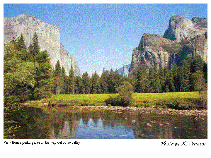 View along the road out of Yosemite
Show me the next picture
View along the road out of Yosemite
Show me the next picture
My final stop in Yosemite was the Tuolumne Grove of 25
giant Sequoia's. It's a smaller
grove than Mariposa (w/500 trees) but it was more convenient and I really just
wanted to see one. I parked the car
and began the easy 1-mile hike on a paved trail.
There's a rich history behind the giant trees which I can't even begin to
explain. The Redwoods are taller
(but skinnier) and the Bristlecones are older (but smaller) yet the Giant
Sequoias are the largest and heaviest living thing ever to appear on the planet
(6100 tons). They can live to be
over 3000 years old. I was in awe.
I really wanted to take a pine cone; but we were encouraged not to
disturb the environment so I didn't. Surprisingly
enough, the pine cones are about the size of a golf ball.
In contrast, the cones of the smaller Sugar Pine can be as large as a
hiking boot. I continued on the
trail eager to see one of the trees. Is
that one? Nah.
Hmmm. That could be one...
maybe not. After this
initial questioning of each large tree I saw, it became immediately obvious that
you'd know them when you saw them. They
completely dwarfed the other trees. They're
so tall you can't get them into the frame of any meaningful photograph.
Thus, any photo you see of people beside the tree will include only the
bottommost portion. As I walked
around, everyone seemed to be in awe of the large trees. Everyone, including myself, was very quiet and respectful.
I'm not sure exactly why, it just seemed to have that affect on people.
I left the grove of Sequoias with the feeling that I'd
seen something very special.
I drove back up through Tuolumne and headed for Nevada.
I was running low on gas but gas in California is substantially more
expensive than in Nevada. I bought
enough gas to get me to Nevada then filled up at a smaller town along the way.
Carson City is reasonably close to the Reno airport and I thought it
might be a cheaper place to stay. I
stopped at a convenience store and asked about reasonably priced rooms at a
hotel/casino. I could've stayed at
a Super 8 or Motel 6 but wanted the Nevada experience. The attendant recommended a place so I went.
It wasn't anything special but I was glad to have a chance to take a
shower and get cleaned up. I went down to the restaurant and ordered biscuits and gravy,
lasagna, etc. The waitress couldn't
believe I had eaten so much. It was
my first meal back in civilization and I was starving. I went to bed shortly afterward.
The next morning I got up, ate breakfast at the restaurant and headed for
the airport.
The trip was great.
The weather, albeit a bit cold, was perfect. And I learned a few things along the way...
I know that I can spend the night in the backcountry by myself.
I know that trips like this (even alone) offer tremendous rewards.
There's so many beautiful and remarkable things to see
and experience. I can't wait to try
it again.
Buying from our sponsors helps support the site.
If you choose to buy later, please return and click through. Thanks!
|
I used an older version of this book
along with advice from rangers and friends to plan my trip. It's an
all around good reference and includes information about lodging,
activities, hiking trails, camping and travel. Follow the link or
click the picture to buy
it from Amazon.com.
I also used a topographic map by Wilderness Press while en route. It's printed on plastic, waterproof material and contains a lot of useful information on the back. This map can be purchased from Amazon.com at a lower cost than the Trails Illustrated maps. (click to buy it). Yosemite topographic maps can also be purchased from Trails Illustrated. Online map. |

Click the graphic above to see more books about Yosemite.
Click here for a sample 3 season backpacking checklist.
These online retailers have the latest and greatest gear.
Thank you for visiting.
Story and photos by Kevin Venator
Travel took place Monday, Aug 30 - Friday, Sept 3, 1999
Disclaimer: information provided in good faith with no warranty or obligation attached. Be prepared for your adventures.
Your safety is your responsibility. Explore with respect.
America's Wonderlands
Copyright 2002 K. Venator